|
|


Editorial
|
Fragments
|
Cahokia I
|
Piasa Creature I
|
Sphinx II
Questions? Comments? Suggestions?
Contact us!
Register
for our Hall of Records Newsletter!
Questions? Comments? Suggestions? Advertising? Press Releases?
Contact us!


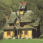
This magnificent structure was modeled after a twelfth-century Stavkirke (Norwegian church).
Note the dragon heads at the peak of the gables. It is only one of the many interesting
structures to be found in the reconstructed Scandinavian pioneer settlement known as Little Norway.
|
|
Nestled in the woods a few miles west of Mt. Horeb, Wisconsin can be found "Little Norway".
Named "Nissedahle", or "Valley of the Elves" by its f-ounder, this restored Scandinavian
pioneer homestead is made up of several authentic Norwegian-styled buildings.
The most prominent of these buildings is the "Norway Building", a magnificent building
built to resemble a "Stavekirke", or Norwegian church (see above). The Norway Building had
originally been built in Norway for Chicago's Columbian Exposition of 1893 as an example of
ancient Norse church architecture. Within this building can be found a large array of folk
art, artifacts, and collectibles from Scandinavia and America.
Other interesting buildings in this restored Scandinavian pioneer homestead include a "Stubbur",
or storage house, which was built on a raised foundation to protect it from contamination from
both floodwaters and prowling animals; a sod-roofed cabin, a style of construction common to
Norway; a Cowbarn, a barn used specifically for housing cattle of all types; a Spring House,
which served as a repository for the water from a natural spring, which was used by the pioneers
as a water source and as a means of refrigeration; a Bachelor's Cabin used by the family to house
family and guests, and many other items of historical value.
Little Norway is located just west of Mount Horeb, Wisconsin, nearby several other interesting
attractions, including the
Cave of the Mounds
in Blue Mounds, Wisconsin, and the
House on the Rock
.
Little Norway is open May 1 through the last Sunday in October, and
hours of operation
vary from month to month. Guided tours are available.
For more information about Little Norway, visit their site at
www.littlenorway.com


|

|
|

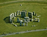
 Stonehenge as it appears today, in the Salisbury plain in the county of Wiltshire, England.
The most visible remains are the upright "Sarsen" stones, arranged in a circle, complete
with Sarsen lintels. Most of the circle has been dismantled, used for building materials,
but enough remains of this outstanding monument to give us a good understanding of its purpose.
|
|
Standing in the Salisbury Plain in Wiltshire County in southern England is a collection of upright
stones popularly known as "Stonehenge". This stone circle represents only a part of the total
structure, much of which has been destroyed by time and weather.
What we now know as Stonehenge today had its start at around 3000 b.c. as a circular "bank and ditch"
structure around 330 feet in diameter. Just inside this circle of raised earth was another circle
of 56 "Aubrey holes". The classical
arrangement of standing stones that we are now familiar with was created around 2000 b.c.
as a circle within the Aubrey hole circle. These upright sandstone blocks, commonly known
as "sarsens", were originally around 30 in number, standing around 13 feet tall, and formed
a circle 108 feet in diameter. Later additions to the circle took place in 2000 b.c. and 1500 b.c.
Placed atop these standing sarsens was a continuous ring of sarsen lintels, forming a complete
stone circle. Five more pairs of these pi-like structures were placed inside the sarsen circle
some time later. Two more concentric circles of smaller "bluestones" were put in place around the
inner circle in 2000 b.c. and 1500 b.c., respectively.
It is not clear who created Stonehenge. Competing theories include the Druids, late Neolithic
peoples, even Merlin, who some legends state magically transported the stones from Ireland (they
had originally come from Africa, transported to Ireland by Giants), and set them up as a monument
to English heroes who had been treacherously slain by the Saxon leader Hengest. The most likely
explanation is the Neolithic one, as the Druids typically made their place of worship in the forest.
The purpose of the monument was to chart the movements of the stars through the heavens, making
Stonehenge in effect a huge astronomical calendar.


|
|

|


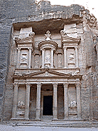
The "Khazheh", the first part of Petra visitors see when visiting, is also the most
well known. Since the release of the film Indiana Jones and the Last Crusade,
(1989), part of which was filmed on location with the Khazneh serving as a backdrop,
tourism to Petra has skyrocketed to the point where Jordanian officials have considered
limiting access to the site to avoid permanent damage to the monuments.
|
|
Petra is an ancient fortress located in Jordan, a middle-eastern country that shares borders with
Israel, Iraq, Syria, and Saudi Arabia. The rock-hewn fortress of Petra is believed to have been
first built by the Nabatean Arabs, who settled in what is now Jordan around 600 b.c., though
none have explained why a nomadic tribe would have such superior skill in architecture. Some believe
that the rock carvings had actually been left by a much older people.
Petra remained under the control of the Nabatean Arabs for the next 700 years, until the Romans
took control of the fortress in a.d. 100. It remained in the hands of first Rome and then the
Holy Roman Empire, and then gradually declined in importance until the Crusaders built a fort there
in the 12th century.
There are numerous interesting places to visit in around the area of Petra-Jordan (conveniently
listed on this
clickable map
page hosted by
raingod.com
).
These include the Siq, the long, twisting natural corridor in the rock that leads to the open area
wherein one first sees the Khazheh, shown above. Also, there is a necropolis (burial place), a Roman
amphitheatre, a "High Place of Sacrifice", Royal Tombs, temples, a Crusader castle, and many more
sites of interest.


|

|
|

 This cross-section of Mound 72 shows the present ridgetop mound, which covers over
three smaller mounds, as well as several surface burials and burial pits. Mound 72
is by far the richest source of artifacts and burial remains to be found at Cahokia.
|
|
Nevada has its Area 51, and
Cahokia
(covered later in this issue)
has its Mound 72, one of the lesser-known wonders of the Cahokia acropolis. On its surface
just another grass-covered mound, indistinct and unobtrusive amongst the array of much larger
mounds scattered across the plain, Mound 72 has yielded the richest collection of artifacts to
be found throughout the Cahokian acropolis.
Mound 72 is a ridgetop mound standing a mere 6 feet tall, so small that it was not even included
in earlier maps of the area. However, archaeologists were tipped off that it might be an important
archaeological site by three unusual characteristics: (1) it lay on the north-south axis of the
city; (2) its orientation was diagonal, i.e., its corners faced the four cardinal directions,
rather than its faces; (3) it was one of only six ridgetop (flat) mounds at Cahokia.
Excavation started in 1967, and continued on for five years, during which time it was discovered
that Mound 72 actually covered over three lesser mounds, as well as a series of surface burials
and burial pits. So far, tens of thousands of artifacts have been found in this site, as well as
the remains of close to 300 people. These people were from all levels of society, all the way from
sacrificial victim to tribal leader.
Based on radiocarbon dating, archaeologists believe that
Mound 72 and the treasures within date from a.d. 950 to 1050. Also, one third of the mound
has yet to be fully excavated, so stay tuned. Also, please make sure to visit our 2-part feature
story on
Cahokia,
starting in this issue.


|
|
Editorial
|
Fragments
|
Cahokia I
|
Piasa Creature I
|
Sphinx II
Questions? Comments? Suggestions?
Contact us!
Register
for our Hall of Records Newsletter!
Questions? Comments? Suggestions? Advertising? Press Releases?
Contact us!


 Lost Cities and Ancient Mysteries of North and Central America
David Hatcher Childress
Rating:
   
One of the popular "Lost Cities" series, this book is a must-have guidebook for mysterious
places in North and Central America. I enjoy Childress' books mainly because he comes across as very honest,
although he engages in too much speculation to be taken at face value. Overall
I find his books a very engaging read, and the speculative aspect, though often
unscientific, is very entertaining. Moreover, the amazing amount of study and
travel he has done brings a certain amount of credibility to his work. I highly
recommend the "Lost Cities" series of books both for their refreshingly informal
approach and for their "infotainment" value. These books are definitely
not for the timid, and certainly not for the closed-minded.
Click
here
to buy this book.
 Lost Cities and Ancient Mysteries of Atlantis,
Ancient Europe & the Mediterranean
David Hatcher Childress
Rating:
   
One of the popular "Lost Cities" series, this book is a must-have guidebook for mysterious
places in Europe.
Click
here
to buy this book.
 Lost Cities and Ancient Mysteries of Africa and Arabia
David Hatcher Childress
Rating:
   
One of the popular "Lost Cities" series, this book is a must-have guidebook for mysterious
places in Africa and Arabia.
Click
here
to buy this book.


 Passion: Music for the Last Temptation of Christ
Peter Gabriel
Rating:
    
This CD received superb reviews (5 stars) and is personally recommended by the publisher.
(The background music on this page is from "Zaar", the eighth track of this CD.)
Click
here
to buy this music.
|
Editorial
|
Fragments
|
Cahokia I
|
Piasa Creature I
|
Sphinx II
Questions? Comments? Suggestions?
Contact us!
Register
for our Hall of Records Newsletter!
Questions? Comments? Suggestions? Advertising? Press Releases?
Contact us!
|
|
